Appalachian Trail (Erwin to TN/VA Border)
Appalachian Trail Conservancy
799 West Washington Street
Harpers Ferry, WV 25425
(304) 535-6331

The Appalachian Trail hugs the border between North Carolina and Tennessee for nearly 200 miles, but it doesn’t enter Tennessee for good until it meets the Nolichucky River, the site of the Nantahala Outdoor Center (NOC) which has a hiker hostel a few hundred feet from the Trail. Erwin is not actually on the AT, but is located about four miles from the NOC. In Tennessee, there is plenty of high country with elevations frequently exceeding 5000 feet. The highest mountains along the Trail, some in excess of 6000 feet, are along the North Carolina-Tennessee state line and included both Hump and Roan Mountain.
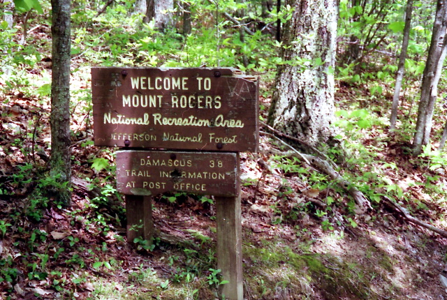
In this section, there are some spectacular balds, including both Hump and Roan Mountain. Their origin is still a mystery but wind, livestock, lightening, and even UFO’s are credited for their creation. Today, both federal and state agencies work to keep the balds clear of trees and brush to satisfy public demands. Roan Mountain is surrounded by the Roan Highlands, noted for their rhododendron gardens and their panoramic views. Hump Mountain is actually a series of balds (including the Little and Big Hump) and all have 360 degree vistas that include Beech Mountain to the east-northeast, Grandfather Mountain to the east, Grassy Ridge and High Knob to the west-southwest, and Whitetop and Mount Rogers to the northeast. The Trail crosses the Tennessee/Virginia line just north of Hampton, Tennessee and south of Damascus, VA. There’s a sign here that marks the boundary of the Mount Rogers National Recreation area.
- click for a short video slideshow of my 1994 hike on the Appalachian Trail
- click for trail photos from this backpacking trip on the A.T.: May 22-28, 1994
- click for a trail journal from this section of Appalachian Trail: May 22-28, 1994
- click for a Daytimer report from Erwin to Damascus (password required)
- click for a trail map of the Appalachian Trail in Georgia, North Carolina, and Tennessee (password required)
- click for a trail map of the entire ~2200 mile Appalachian Trail
- click for a profile map from Sams Gap to Moreland Gap (password required)
- click for a profile map from Moreland Gap to Iron Mountain (password required)
- click for a profile map from Iron Mountain to Damascus (password required)
- click for a USFS map from Erwin to Damascus (password required)
- click to purchase the guidebook Hiking Tennessee with more hikes in this area
- click for more information on the Appalachian Trail
- click for Appalachian Trail hiking and backpacking books